The Creek Road Graveyard
War of 1812 Graveyard at Creek Road
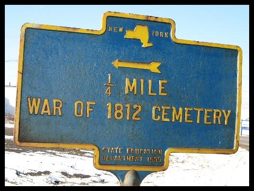
A history of the War of 1812 cemetery located on Aero Drive in the Town of Cheektowaga, New York
Growing up in the area of the War of 1812 graveyard I have always been curious about it, and the history of the area surrounding it. I can remember passing it for the first time as a child and being fascinated by the old canon and white crosses. Here are my findings.
From the book Snake Hill: An Investigation of a Military Cemetery from the War of 1812
"The site for the new General hospital was selected on 29 July 1814 on the recommendation of senior surgeon, Doctor Ezekiah Bull. Thus, 37 ha and the stables of Raphael Cook's farm were leased for the construction of a general hospital. Ironically, the contract specified "no burying place in the premises" Source
So I assume the goverment deceided to place the dead on a peice of property that was owned by the Holland Land Company at the time..
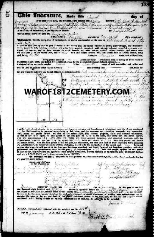
On 11 January, 1816 Wilhem Willink et al (Holland Land Co.) sell the property containing the cemetery to Benjamin Barton. (Liber 3 page 133) This is the first transaction and there is no mention of the graveyard in the deed.
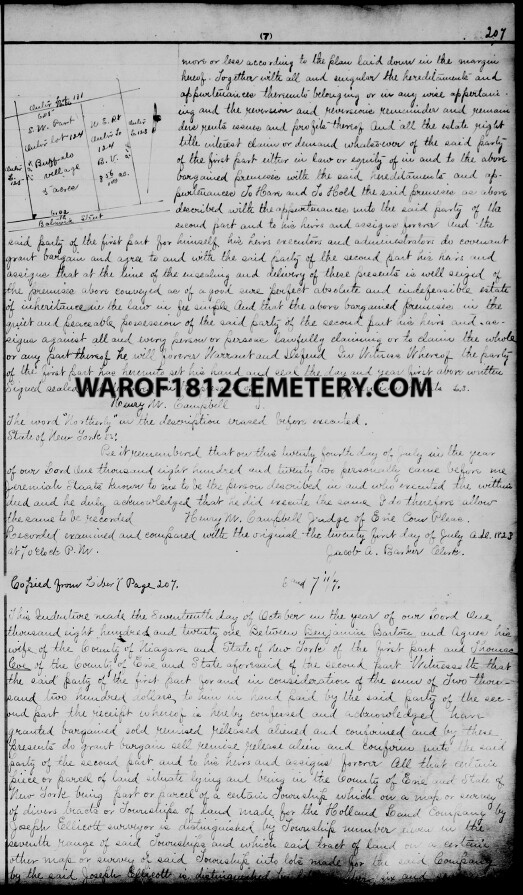
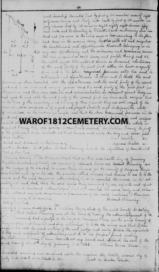
The 2nd land transaction took place on October 17th, 1821 Barton sells property containing the cemetery to Thomas Coe. (Liber 7 page 207)
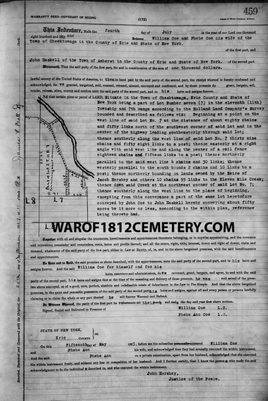
The 3rd land transaction for the property was on July 4th,
1851 William Coe sells property containing the cemetery to John Haskell. (Liber
172, page 459)
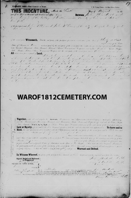
The 4th land transaction was on August 6th, 1851 John Haskell sells the cemetery property only (parcel A) to John Bliss and John R Evans. (Liber 123 page 19) "The ground should not be disturbed or encroached upon" This was the last time the land was held in private hands before being deeded to the Buffalo Historical Society on July 12th, 1898
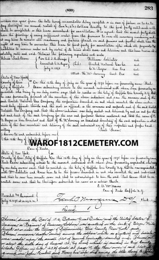
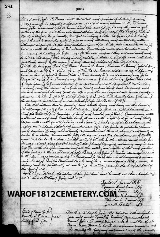
Then on July 12th, 1898 the estates of John Bliss and John R Evans deeded the cemetery (parcel A) to the Buffalo Historical Society. (Liber 833 page 283)
In an account as described in the Buffalo cemeteries: an
account of the burial-places of Buffalo, from the earliest times: read before
the Buffalo Historical Society, February 4, 1879.
In this connection it would not be right to omit a notice
of the
soldiers' burial place at Williamsville.
— About six thousand of our army raised during the
first year of the war of 1812-15 and sent on to protect our fron-
tier at Buffalo, went into winter quarters at Williamsville village,
eleven miles north of Buffalo. Their encampment at that place was
just north of the main road, and contiguous to the village, on the ex-
tensive premises then owned by the enterprising merchant and
milling firm of Juba Storrs & Co. This ground continued to be oc-
cupied by our soldiers more or less during the war. Sickness as is
usual in camp prevailed among them ; and some two or three hun-
dred died and were buried on the grounds adjacent. Since then the
village has spread, covering the ground where they were buried, and
long since not a vestige of a grave was left to be seen. There has
been no one to look after or care for their bones when exhumed, as
they often were, in excavating cellars or making improvements such
as are necessary in a growing village.
There were quite extensive barracks built on the bank of the
Eleven Mile Creek, a very healthy, eligible place ; it being retired
from the immediate scenes of conflict and about one mile above the
village. It continued to be our General Hospital for sick and
wounded soldiers during this war.
During the three years of the conflict, many of our soldiers died,
and were buried at the side of a field near by. The ground that
contains their remains comprises about half an acre, lying on the
southwesterly side of a public road ; the Eleven Mile Creek running
parallel and adjoining.
Two of our townsmen. Col. John Bliss and John B. Evans, feeling
an interest that this ground should never be disturbed or encroached
upon, procured the title by a warranty deed from the owners, John
Haskel and wife, to themselves, dated August 6th, 1851, and duly
recorded. They have both since deceased, leaving the title in their
heirs. The number of our own soldiers buried on this ground is
supposed to be three hundred or more ; and in one retired corner
lie nearly one hundred of our enemies who were wounded, taken pris-
oners and died. Many of the latter were captured at the desperate
sortie the British made on Fort Erie August 14, 1814, and the
blowing up of the magazine. There were several hundred prisoners
taken at this encounter ; many of them were wounded most horribly,
having been blown up when the magazine exploded.
On the second day after the sortie, I saw a number of wagon loads
of those blackened and maimed British soldiers as they stopped in
front of my father's house on their way to the hospital.
Recently with one of the oldest residents of the town, Hon. T. A.
Hopkins, I visited this burying place. There was not a slab or
monument of any kind to be seen to designate the graves. Only
the uneven hillocks marked the spot that contains the bones of our
unhonored dead.
This ground is a little elevated from the surrounding land and
road adjoining. On the border of two sides stand ten sugar maple
trees, from one and one-fourth to two feet in diameter ; all but one
in a fine healthy condition. I have no doubt they were planted there
by the comrades of those whose bones now occupy this ground.
The tenth tree is in a state of decay, and like many of the human
race is beginning to die at the top.
It is known only to a few living witnesses that this spot of ground
contains the graves of some of our dead soldiers. Our Government
ought to erect at this beautiful retired place a suitable monument
to their memory and provide for removing thither the skeletons of
others, when found in excavating in the village.
Source
As you can see from this earliest know photograph of the graveyard the five sugar maple trees on the eastern boarder of the graveyard as described in the historical account.
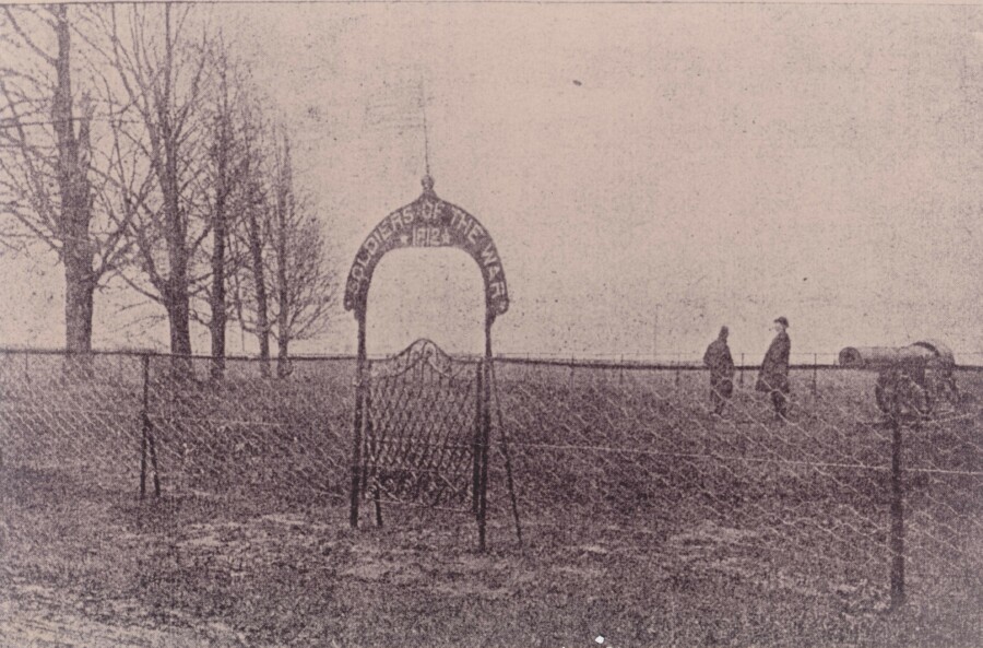
Possibly the oldest known photograph of war of 1812 cemetery. Most likely
1898 or 1899
after the estates of John Bliss and John R Evans deeded the cemetery to the
Buffalo Historical Society.
Photo courtesy of David Przepiora of cheektowagahistory.com
On 9 November, 1898, the Buffalo Historical Society placed a
cannon at the cemetery. The cannon was a Parrott Gun taken from the north
end of the circle at The Front and was suitably inscribed to the memory of
the dead soldiers. An arched gateway was installed with the letters "Soldiers
of the War of 1812" cut from galvanized iron. On August 25th, 1942 the
original cannon (acquired in 1898) was presented to the Bethlehem Steel Corporation
to be used as scrap metal for the war effort.
As described in the Buffalo cemeteries: an account of the burial-places of
Buffalo, from the earliest times: read before the Buffalo Historical Society,
February 4, 1879.
"On the border of two sides stand ten sugar maple trees,
from one and one-fourth to two feet in diameter ; all but one in a fine healthy
condition. I have no doubt they were planted there by the comrades of those
whose bones now occupy this ground. The tenth tree is in a state of decay,
and like many of the human race is beginning to die at the top."
I believe 5 sugar maple trees on each side which are shown on the left of
the photo.
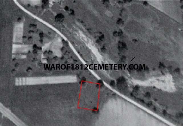
After careful looking through the archives for maps and aerial photographs
of the area of the graveyard I was able to compile scaled overlay on to Google
Earth of the area of the graveyard.
The next image is the 1927 aerial photograph of the graveyard, the cemetery marker on the map is location of the canon at present time. The three remaining sugar maple trees are visible of the original 10 planted and the black dot at the yellow line is possibly the Parrott Gun installed in 1898 By the Buffalo Historical Society.
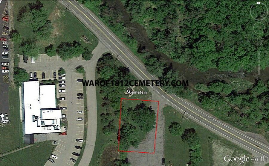
Present day satellite image of graveyard red lines overlaying the boundary of original graveyard from 1927 aerial photograph.
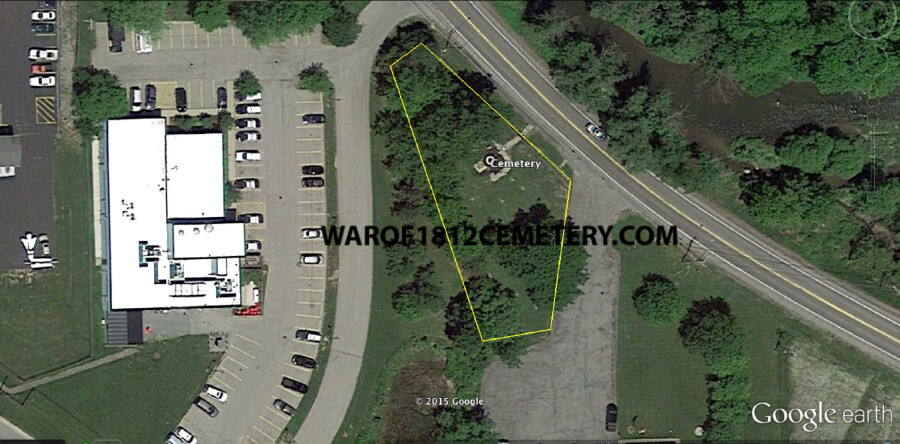
Yellow lines represent current day graveyard boundaries
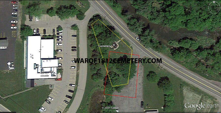
In this image you can see the present day graveyard boundaries marked in yellow and the original graveyard boundaries marked in red. As one can see a good portion of the original graveyard is now a driveway and parking area.
Please send any questions or comments to
warof1812cemetery@gmail.com
© 2016 warof1812cemetery.com